
Dozens of people turned out to the Tucson Pima County Bicycle Advisory Committee to, mostly, voice their concern about a potential shared-use path through Tucson Mountain Park. Read yesterday’s post for background on the issue.
Assistant County Administrator Nanette Slusser said the proposed paths through the park were just two of the many options that the county would consider in the coming years. She said that the discussion was premature.
She said the county doesn’t have an official plan or money to implement any type of path in the area, but have a goal of connecting the future CAP canal path to the Santa Cruz path.
“I’ve been warned many times by many people not to go through Tucson Mountain Park,” Slusser said referring to the 60-80 emails she has received about the routes. “I’d prefer to find an alternative. We are not going to do something that annoys our largest constituents.”
Carolyn Campbell, the executive director of Coalition for Sonoran Desert Protection said when she was approached by the county, the one and only proposed route utilized the Starr Pass trail through Tucson Mountain Park, which is why the various stakeholders were so concerned.
Sonoran Desert Mountain Bicyclists President, Zach MacDonald said SDMB has no official stance at this point won’t have an official stance until their next board meeting, but that is was clear the Starr Pass route was the path the county were most interested in when the they approached SDMB three months ago.
The documents that were circulated (see below) with the two potential routes included the estimated costs of each route for a colored concrete path as opposed to an asphalt path.
Slusser said she couldn’t say that the a path through the park was off the table because that decision needs to come from her bosses.
“It doesn’t have to go through Tucson Mountain Park,” Slusser said. “As a matter of fact, it’s unlikely at this point that it will from what I have heard, but we are not going to take it off the list because we want to tell people we looked at all of these options. That is how we are supposed to plan.”
Slusser said the county is looking for other routes to connect to the paths that wouldn’t upset residents and people who use the amenities in the area.
She said there will be a lot more routes the county will consider and lots of opportunities for public input.
That’s something MacDonald appreciates.
“It was good to hear from Nanette Slusser that they were really just fact finding and looking att all of the different alternatives,” he said. “They are going to study the alternatives and bring those to the public. The mountain bike community and trails community will have plenty of opportunity to weigh in the best route.”
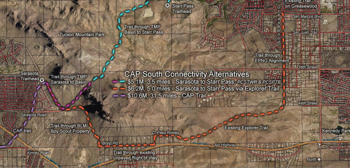
Download the entire CAP trail and connection routes here.
The attached overhead map of the Loop CAP trail and connection routes is awesome. Where did you find it? Do you have any similar maps for the other parts of the Loop? I’d love to have some way to track which sections of the trail are recently completed and planned for the near future.
CodyM48The Pima Co. site at http://www.pima.gov/theloop/ has some good information but I don’t know how often they keep it up-to-date. I was handed a Loop map at the Cyclovia this year, but I think it’s already out-of-date.
@Scott Lunt Thanks, Scott. I’ve used their website before, but as you mentioned, the maps are typically out-of-date.
I’ve been doing periodic Loop exploration rides to see if there’s any new pavement anywhere.
Well, yes it all seems odd and offensive. Of course planners think of many options, that’s what they do as Nannette Slusser correctly points out.
But why does the unelected bureaucrat Nanette Slusser then turn around and arrogantly and condescendingly tell the public that funds her activities to *sit down and shut up* (on the sly pretense of “premature”) when it expresses concern and skepticism? The answer is in this question.
Meanwhile she has a backlog of incomplete projects.
Red Star
She didn’t tell anyone to shut up. She provided information and listened to comments. If anyone was off sides at the meeting, it was the folks in the audience who kept saying they didn’t want an asphalt strip thru the pristine desert, after Ms. Slusser had explained that if a paved path were to go thru the area it would be concrete colored to match the surroundings. I’m for a paved path, I just stipulate that it must not go over existing hiking / biking trails. I’d run it from the squeeze to 36th St., not any of the routes shown on the maps.
3wheeler
“She said that the discussion was premature.”
‘largest constituents’? Is that a fat joke?!
3wheeler Red Star I’d also just say bicyclists were told by the streetcar team that they would use the block rail. We know what happened there. They were told that the Warren underpass would be open for bicyclists. We know what is happening there. They were told that the route would incorporate lots of safety aspects for cyclists along the streetcar route, which happened to be one of the most popular bike routes in the city. What do you think the people who are crashing on the tracks think of the safety treatments?
Clearly the streetcar team and the county are different entities, but I don’t think there is a lot of trust between government officials and bicyclists right now.
I can understand why people are skeptical especially given what Carolyn Campbell and Zach MacDonald said regarding the county approaching them with one route and one route only.
MikeMcKisson 3wheeler Red Star
There’s no doubt that the streetcar people lied to get a contract worth millions of dollars to them. I’m not sure why the county would be deceptive about this. I don’t see a gain for them. There may be, but I don’t see it. The Explorer Trail route option is too steep in parts to be used by anyone other than serious cyclists. The mass of people won’t use it and will be upset by money being spent on it. Routing a path from the squeeze to 36th St. in a direct manner is relatively flat, and it is completely away from any existing trails except at the very ends. The problem with going to 36th is there is no way to get off of 36th until La Cholla.. What I really don’t get, and I should’ve asked Ms. Slusser, was why her routes end up going north at their east ends. That’s not the shortest way to the Santa Cruz, which is east. One route goes to the Starr Pass resort area. There’s no way to get to the Santa Cruz that way without going on public roads or private property for miles. The Explorer Trail route option turns north on the natural gas pipeline right of way and ends at San Marcos. I don’t see a way to out of there either. I suppose they might continue north to Anklam and run across Pima College to get to Mission and Speedway. They still have a challenge to get to the river from there. As I see it, 36th is the only reasonable route possible and it’s not perfect. If you’re east bound on 36th, once you get to 36th and La Cholla, you can get off of 36th and ride thru publicly owned land to Mission Rd., then cross Mission and get back on publicly owned land and then get back on a 1/4 mile section of public road before getting to Cottonwood Ln. and then you’re at the river. An alternate route to get off of 36th is to head south on the gas line ROW and get to Kennedy park. You can get to river that way thru publicly owned land but it’s a little longer over all. It does get you off of 36th a half mile sooner tho. Over all, I’d have to say that last option I described is best because it only slightly interferes with current hiking / biking trails, it’s the flattest, it requires no new land purchases, and it requires only .86 miles of riding on a public street, 36th. Plus, it may be possible to build a separated bike path along a portion of 36th.