
Pima County announced the launch of an interactive map highlighting The Loop. What they didn’t say however is that the Tucson bike map also highlights the entire region’s bicycle routes as well as hiking and biking trails in Pima County.
The interactive map uses over 30 different GIS map layers to provide detailed information about biking throughout the region.
The map also has a mobile optimized version.
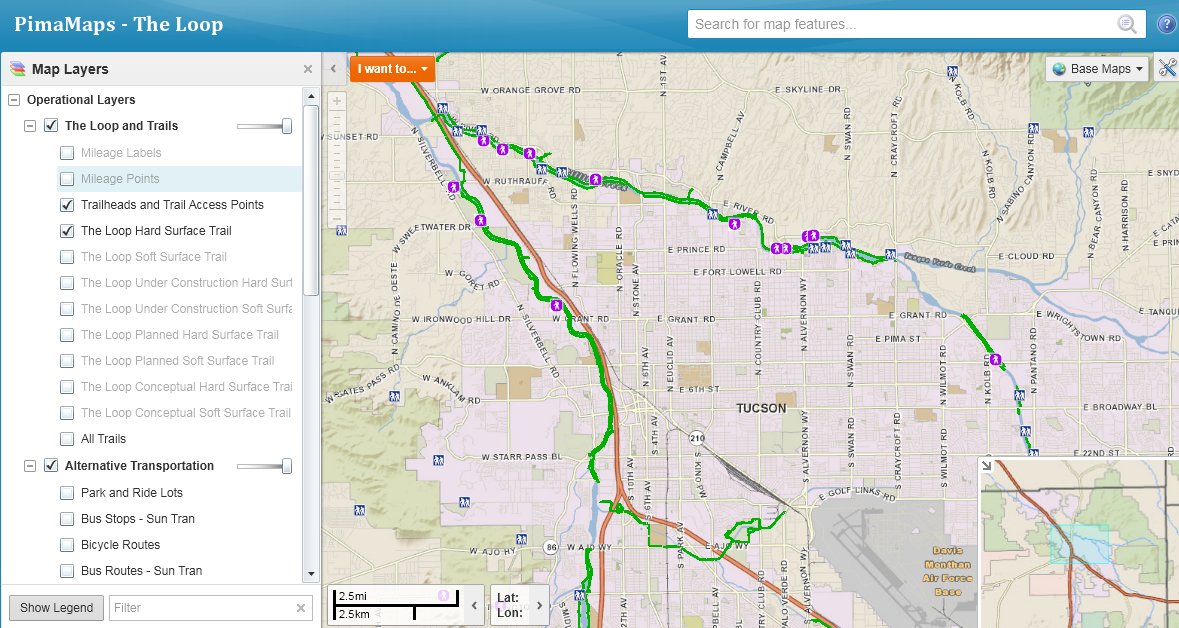
Here’s a snippet from the county’s user guide:
-
Open/close the map tools by double-clicking on the blue bar along the top of the map or by clicking the tool symbol in the upper right corner of the map.
-
Under the Getting Around tab, check out the FAQ or Help Videos. Try zooming in and out, and panning around.
-
Under the Maps & Data Sources tab, click on Show Layers, expand one of the layer categories and check and uncheck boxes to turn different map layers on and off.
-
For example, under Alternative Transportation, turn on the Bus Stops and Bus Routes layers to see how to use public transportation to get to The Loop. Under Base Maps, uncheck Street Basemap and check Imagery Basemap to see aerial imagery.
-
Also under the Maps & Data Sources tab, click on Enable Map Tips and then hover over map features (pathways, trailheads, access points, etc.) to get additional information about them.
-
Under the Analysis tab, click on Measure Distance, then click on your starting point and along your route, and double-click on your destination. You can read the results in feet, yards, meters, kilometers or miles, and save the route.
-
Under the Tasks tab, you can add text, lines or shapes to the map and save them. And you can print or export the maps you’ve saved.
-
Right click anywhere on the map or click on the orange “I want to…” rectangle to do a number of routine tasks.
Check out the map at pima.gov/theloop.
The mobile version works on a Windows desktop and on a Windows laptop (so you don’t absolutely have to have Silverlight). On an android tablet, it is tedious like everything else with a tablet.
I didn’t try to do any of the tasks suggested by the users guide, but the “Smart Phone Optimized” version works nicely on regular browsers if you don’t want to install the Silverlight malware on your computer.
Unfortunately, the map doesn’t show closures. There’s a sewer project going on right now on the south side of the Rillito between Alvernon and Dodge, and the map makes no reference to that. The Alvernon underpass is closed, and there’s no detours. Pima County is apparently expecting cyclists and pedestrians to cross Alvernon at-grade instead.
Unfortunately the map doesn’t show closures.
Right now there’s a sewer project closing the south side of the Rillito between Alvernon and Dodge. The Alvernon underpass is closed with no detour. Apparently, Pima County wants cyclists and pedestrians to cross Alvernon at-grade instead.
is anyone else having trouble with the map while using Chrome?
[…] The Loop Interactive Map […]